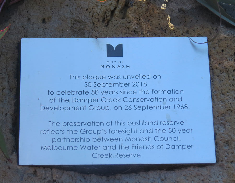
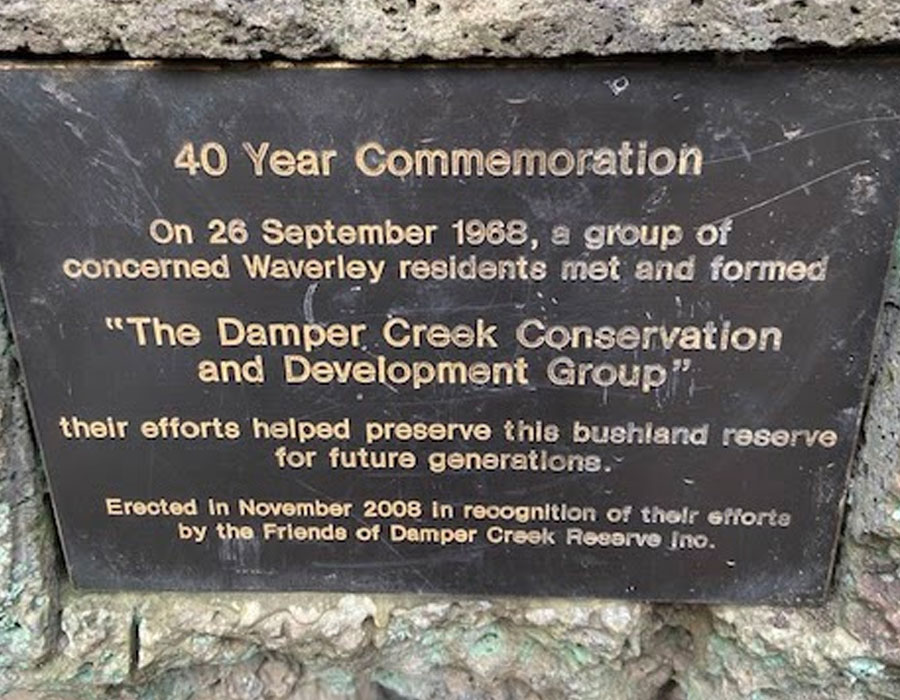
In 2008 the annual End of Year Barbeque incorporated the 40 years celebration (26/9/1968 – 26/9/2008) of the saving of the Damper Creek and surrounding bushland. The event was well attended by many residents, current and past members including many original committee members of the Damper Creek Conservation and Development Group. A plaque was unveiled on “Mushroom Rock” near the Alice Street (Palma’s Plummet) bridge to mark the occasion.
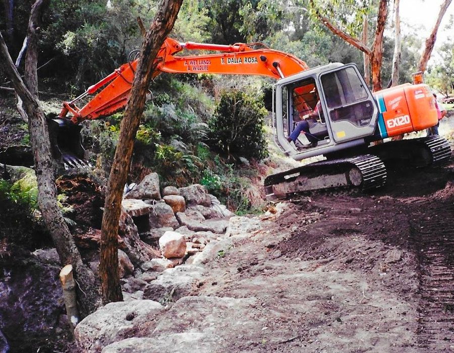
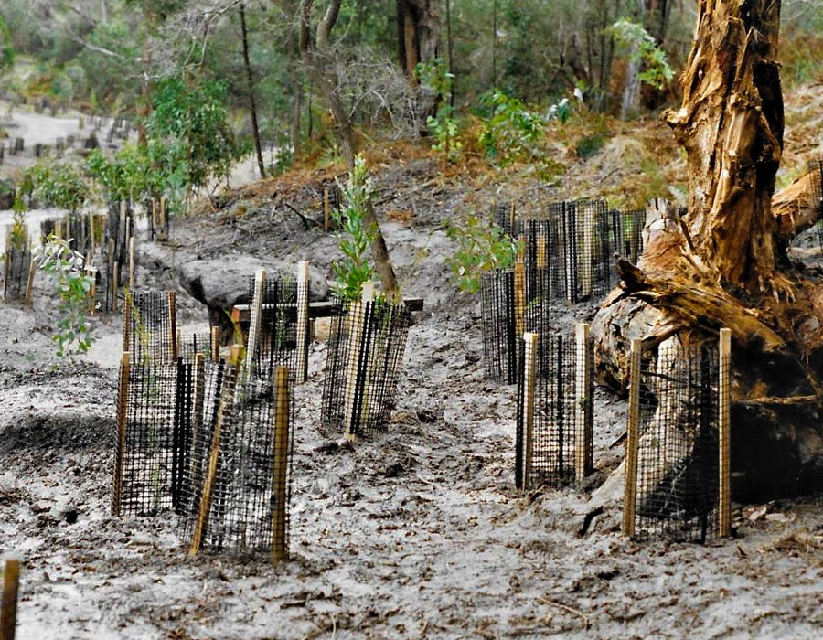
In 2009/2010, and later years, further creek rock work by Melbourne Water was undertaken in Damper Creek East (including desilting) to attempt to slow the water flow during torrential rain events to prevent scouring of the creek bed and subsequent erosion. This work has met with limited success.
Over recent years, desilting of the main ponds (located in the main arm of Damper Creek itself) has been carried by the Monash Council and the build up of silt in these locations is reviewed for further action from time to time. Silt build-up caused by erosion is a continual problem in both arms of the creek.
THE TEXT FROM AN ADDRESS BY GUEST SPEAKER PETER DAVIES FOLLOWS –
40TH ANNIVERSARY PLAQUE UNVEILING – HELD IN DAMPER CREEK ON 29 NOVEMBER 2008
(PETER DAVIES WAS AN ORIGINAL MEMBER OF THE DAMPER CREEK CONSERVATION AND DEVELOPMENT GROUP FORMED IN 1968 – AND IN THE YEARS FOLLOWING WAS ELECTED AS A COUNCILLOR AND ALSO THE MAYOR OF THE CITY OF WAVERLEY).
With great diffidence I have accepted the task of unveiling this plaque which commemorates the 40th Anniversary of the Damper Creek Bushland Reserve by the Damper Creek Conservation and Development Group.
Prior to the unveiling I wish to offer a few reflections upon the background of this reserve. I also wish to express on behalf of all residents of Monash/Waverley the debt of gratitude that is owed to the group for their ongoing commitment and dedication in regard to management aspects of the creek reserve.
The existence of the reserve, within the boundaries that it possesses today, only became a reality through the vigorous efforts of the founders, of the Group in 1968 and 1969 who battled to gain Council recognition of its responsibility to maintain the Reserve, as defined in the then Melbourne and Metropolitan Board of Works Planning Scheme, in perpetuity for future generations.
I was an outsider that happened to be drawn in the events that unfolded as the local community sought to defend the creek riparian elements from development forces.
I seek your patience as I offer some commentary on matters that lead to the formal establishment of the Reserve.
In the mid 1920’s a Melbourne Metropolitan Town Planning Commission was set up with representatives from the City of Melbourne and the major groups of surrounding municipalities, plus technical experts and a representative of the railways was added. The Commission was charged to draw up a plan of development for Melbourne. This plan would represent the first formal overall strategic document that would provide a guideline for the future development of the Melbourne metropolis.
In the early stages of the Commission it recommended a new rail line from Darling to Glen Waverley and a specific report was prepared on this project. This report not only dealt with the proposed railway but it also embodied an appraisal of the manner in which areas adjoining the proposed railway could be developed/planned. The document also made reference to existing waterways in the area and the principle was raised of protecting the riparian elements of these waterways which lay within the boundaries of privately owned properties.
Subsequently in 1929 the Commission produced a Plan of General Development, Melbourne. It was intended that this plan would be given some statutory force, as up to that time there was no formal strategic planning document for the metropolis as has been referred in earlier commentary,
In the 1929 Commission report specific reference was made to the need to introduce a significant reservation along Damper Creek and also the need for a reserve over land that we know as the Federal Street Reserve was also indicated. It is known that the then Shire of Mulgrave took an active interest in the planning principles that were contained within the Commission documentation.
Unfortunately the Great Depression of 1931occurred and events following that depression resulted in the Commission concepts being set to one side. It was not until 1954 that actual procedures were put in place to produce a metropolitan planning document,
The ability to prepare and gain approval to statutory planning scheme came into being in 1944 but most Councils were reluctant to become involved the formal processes of planning.
In 1949, the Victorian Government asked the Board of Works to prepare a planning scheme for a defined metropolitan area, broadly incorporating municipalities within a 15 mile radius of the central city, with a 25 mile extension to take in the Frankston area.
The planning scheme operated for many years as an interim control until gaining formal approval in 1968. It contained a series of statutory maps and an enabling ordinance. It established land use controls by means of zones, and reservations of land for various public purposes, including new major roads and also proposed open space areas.
The MMBW in the course of the preparation of the metropolitan scheme took up many of the planning principles that were embodied in the earlier 1929 Metropolitan plan. As a result a proposed open space zoning was placed over the Damper Creek area and also over the Federal Reserve area.
The Shire of Mulgrave and later the City of Waverley did not possess its own planning scheme but it did operate an Interim Development Overlay by which it controlled planning matters. This control generally recognized the MMBW controls plus other local policies held by municipality. No strategic statement of policy in regard to waterways existed in any Council planning documentation.
In earlier development in the 1950’s and 1960’s the MMBW generally viewed local creeks as drainage reserves which would eventually require upgrading to a formalized concrete channel to enable maximum efficiency in removing upstream drainage waters. This is best evident by the manner in which Gardiners Creek was handled in the Jordanville/Holmesglen area and where that creek passes through open space areas in the former housing Commission area.
At a later stage the MMBW, in conjunction with input from community groups seeking greater sensitivity in dealing with local water ways, became attuned to utilising underground drainage in conjunction with the retention of vegetated waterways, allied with the introduction of retarding basins. These aspects are reflected in both Damper Creek and more particularly in respect of Scotchmans Creek, particularly between, Huntingdale Road and Blackburn Road The City of Waverley/Monash has reaped significant community benefits through such action that was undertaken by the MMBW and which is now being administered by Melbourne Water.
My specific involvement with Damper Creek arose in 1968 when I read in a local paper that residents adjoining the creek reserve and also in other nearby areas were extremely perturbed at the possibility that riparian elements and other nearby vegetated areas could be impacted by proposed land development.
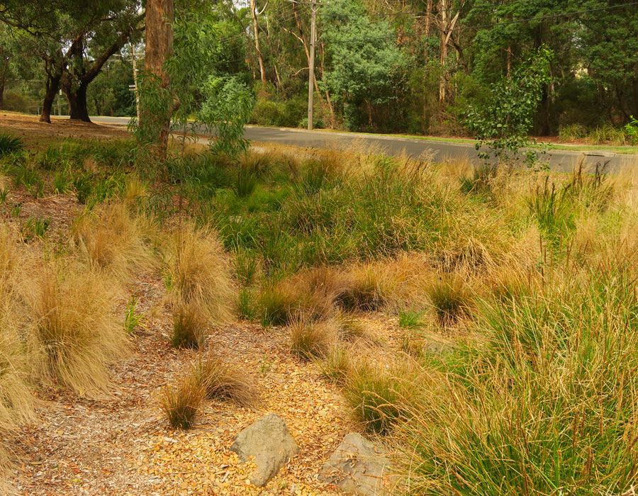
I can vividly still remember walking from our home near the Mt Waverley Water Storage Facility/Mount Waverley Reserve to the Damper Creek area and strolling up the creek from High Street Road through to Stephensons Road. It was immediately evident that this was an area which possessed great potential both as a bushland reserve and also as passive recreational parkland.
I was aware that the residents were extremely irate and their anger arose not only from an apparent intent by the Council to endorse the subdivision of significant elements of this area but also from the fact that portions of the land through which the creek flowed were owned by a former City Valuer.
After inspecting the area I then investigated the relevant planning controls over the subject land. I was pleased to note that it possessed a Proposed Open Space zoning designation on the MMBW planning documentation. Such zoning indicated that there was an intent that the – Council would eventually be seeking to purchase/compensate the relevant owners for the subject land.
I decided to attend the public meeting of this matter. The meeting was held at the home of Barry and Beverley Counsel in Oak Court. This meeting was attended by a large vociferous crowd and a number of Councillors were present.
My prime purpose in attending the meeting was to provide a planning perspective, if required, and advise those seeking to retain the areas for public open space to remain focussed on the processes to be observed in seeking to attain such an objective. From my planning background I was aware that many people found planning a complex and confusing area – even more so today – and that they could waste a lot of time and energy if they did not follow logical processes.
It was evident that the organisers of the meeting were extremely capable persons and well attuned to marshalling forces to have a significant impact on the Council.
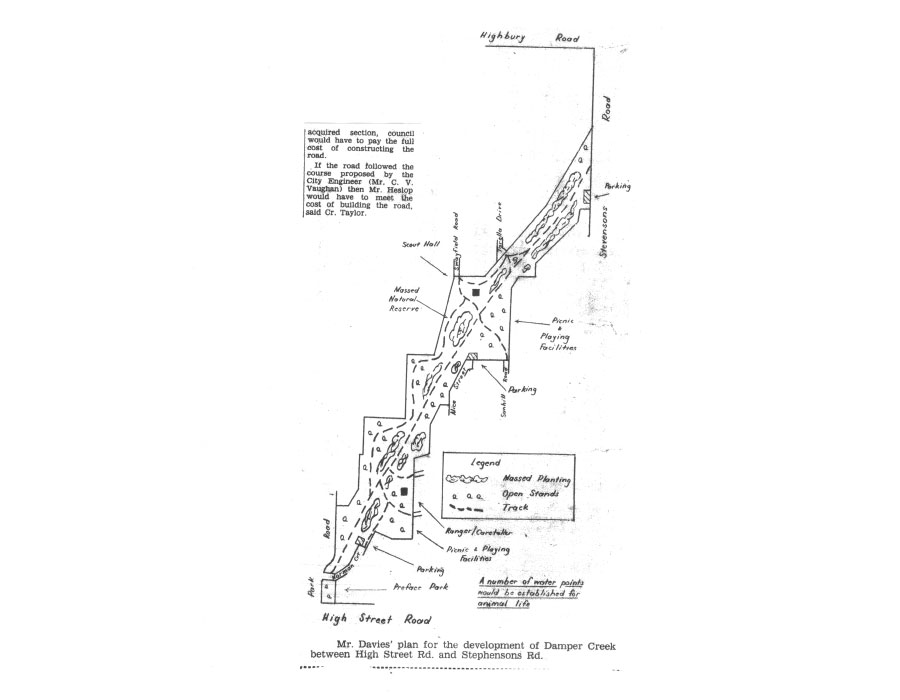
The next thing I knew was that I was recruited into an action group, and I was preparing plans of the general principles of the manner in which Damper Creek area should be developed as a conservation/passive parkland area in accordance with the boundaries that were defined in the planning scheme documentation.
The group also decided to embody in its ambit of interest the bushland area on the northwest corner of High Street Road and Stephensons Road which it was desirous of bringing into public ownership.
Things then happened at a relatively rapid speed. The group sought a delegation with Council on the issue and a friend of mine, a fellow surveyor John. Taylor, who was one of the Councillors for the Ward, aided in gaining a hearing, I can remember appearing before Council officers and a number of the Councillors at the council officers. I think Barry Counsel was a lead member and number of other Damper Creek stalwarts attended. Barry was well attuned to the pressures that were necessary to be applied to ensure that Councillors were aware of the intensity of public opinion.
I can also recall the City Engineer, Mr. C. Vaughan, asking if we were seeking to introduce a level of development that would be akin to that which exists at Hedgeley Dene Gardens in Malvern – a highly formalised linear parkland and my responding that the group wished to maintain a bushland setting with a high level of informality. A willingness to be voluntarily involved in management was also raised.
Then followed a situation which had a significant impact upon my life and that of my family. One of the Ward Councillors, due to personal reasons, decided to resign, and Barry and his merry fellow members apparently decided that it was necessary to run a candidate at the by-election. Even to this day I am unaware as to how it eventually transpired but the group focussed upon me to stand against another nominee who was locally viewed as a ‘shoe-in’ for the position. I still cannot believe that I accepted such. a challenge and I can remember that electioneering and door knocking were extremely wearing experiences.
Much to my amazement the final outcome was that I was the successful candidate due to the extremely effective campaign organised by the Damper Creek residents and aided by my friend John Taylor and a wide range of support from other groups. This resulted in 13 years of Council service in which I pursued consistently open space policies as well as a broad range of planning and other community related issues.
Prior to my election to Council I also found myself faced with the need to prepare a substantive case to place before the then Administrative Appeals Tribunal in respect of a test subdivision proposal brought forward by the land owner. The subdivision proposal in regard to land at the corner of Park Road and High Street Road was not opposed by the Council as it did not wish to be confronted with a need to acquire the land from the owner – a situation that would automatically occur if the Council opposed the subdivision. The Council. considered that there was no valid reason to expend monies upon the purchase of the subject land for open space. A street construction program for Park Road had already included the construction of driveways for the proposed lots.
This was a rather trying and emotive experience and I was extremely grateful for the support given to my presentation by the significant presence of the Damper Creek residents. Our case centred around the land having a valuable role as a “preface park” for the upper elements of Damper Creek and it also relied upon the fact that the concept of a linear riparian reserve along the creek had first been raised in the mid 1920’s, allied with the fact that current statutory planning maps reflected an intent for the land to have a major open space role.
Much to my surprise our concerns were upheld as I thought that the Tribunal would be highly unlikely to consider that the Council should be required to purchase the subject land. Much celebration ensured and fortunately, once the Tribunal decision was handed down, it was to the Council credit that it then decided to make a commitment to the establishment of the overall reserve.
Again MMBW made a major contribution in assisting the Council in funding the land purchase. Through the then Metropolitan Improvement Fund the MMBW was prepared to lend monies over a seven year period to a Council wishing to acquire land for open space and no interest would be charged over the first three years of the land.
No sooner had this matter been settled, a need arose to vigorously defend the purchase of Federal Street land and this represented a particularly arduous time in my initial period on Council.
These pressures were also made more complex as numerous other groups were seeking purchase of land for open space in areas where there was a paucity of recreational areas. Fortunately the Council was prepared to initiate a review of open space needs and also under the guidance of a new City engineer the concept of outline strategic planning gained momentum as new areas were opened up.
Service on the Council led to gaining experience in a wide range of issues both at Council level and also at the broader metropolitan level. At Council level I had the privilege of being Chairman/Deputy Chairman of the Camberwell/Waverley Regional Library for nearly 10 years and I had the opportunity of bringing forward to Council proposals for both the Glen. Waverley and Jells .Road Branch Libraries- at a time when, Mt. Waverley was the sole Library for. the municipality. I was also interested in Strategic planning. issues for. Waverley and in my year as Mayor I was fortunate to gain Council support on the development of strategic concepts for both Mt. Waverley and Glen Waverley which are now generally reflected in the commercial elements as they exist today.
At a metropolitan level I was appointed as the Waverley Commissioner of the MMBW and in conjunction with such position chairing working groups to development objectives to aid in the establishment of Jells and Westerfolds Park, evolving strategic objectives for metropolitan major parks such as Dandenong Valley and the Yarra Valley. Following the completion of my Council service serving as a foundation sessional member on Planning Panels Victoria and chairing well over 200 planning hearings, environmental assessments, advisory committees of broad range of major planning related matters and EPA review conferences. All this arising from those Damper Creek enthusiasts who prodded me forward to become a Councillor.
In closing I wish. to stress the continuing need to be alert in regard to the protection of the boundaries and all land components of Damper Creek. Unfortunately we are confronted with a current Council that has a standard policy approach of constantly reviewing its land holdings as a financial resource for to aid in assisting the funding of Council projects, such as the Oakleigh Pool project.
Since the formation of the City of Monash some tens of millions of dollars have been raised from the sale of Council property and many of the parcels sold are small portions of open space that have been skilfully excised for public disposal. A number of these parcels were areas that I had fought to be appropriated for public open space/public purposes and I have experienced great disappointment at their disposal.
In addition to facilitating such disposal, when the new format planning schemes were introduced to supersede the MMBW scheme, the Council ensured that many of its land parcels with a potential for sale held a residential zoning rather than an open space designation. Such approach greatly facilitates the ability to dispose of the subject land and avoids a rezoning procedure which can be protracted and possibly more complex.
Just recently I contested the sale by Council of land in Lesay Court, that had been designated on the initial subdivision as a Municipal Reserve that played a linkage role into the Scotchmans Creek Reserve and which had came into Council ownership on transfer that I had personally signed as a council representative, where such a situation existed. Unfortunately VCAT did not support my pleas and it upheld the right of Council to dispose of the land, particularly as it possessed a residential zoning.
I draw your attention to land in Bengal Crescent that forms a portal entry to the general upper environs of Damper Creek and also an entry site to Scotchmans Creek in Sadie Street, both are zoned as Residential; I encourage you to actively pursue the Council to remove the Residential zoning and introduce a Public Park and Recreation zone over land it holds in Bengal Crescent to which it has ownership and also extend such zone, allied with a Public Acquisition Overlay over the adjoining vacant lot that is currently not in the ownership of the Council but is being maintained by Council.
I would also be vigilant in regard to fringe elements which the Council may deem as being “ripe for the picking”.
I would also commend you to inspect land on the south side of Waverley Road just past Forster Road where an aged persons facility is near completion. It represents a fine example of how to rape Scotchmans Creek and its riparian elements. Such impact has arisen from the dogmatic determination of the Council to not being willing to purchase land for an appropriate public reserve extending approximately 10 to 20 metres beyond the upper banks of the creek.
In this project the Council has required only a 3 metre pathway easement to be provided and it is not prepared to have any responsibility for any level of maintenance over riparian elements or areas outside the limits of the pathway. Due to a complete failure to prescribe well in advance the position of the proposed pathway though specific on-ground positioning, allied with adequate protection of such area from any impacts from the proposed development, the Council has completely lost control of the situation.
It breaks my heart and in three attempts to oppose such an impact before Tribunals and a Planning Panels hearing: (a) a proposal for unit development on the site where a 30 metre easement coinciding generally with the creek was imposed by the Board Chairman;
(b) the new format planning scheme was introduced and Council support was sought for a Public Park and Recreation zone over a reserve area approximately 15 metres either side of the creek centre line which generally accorded with the .above easement but the principle was rejected by the Planning Panel; and
(c) later at an appeal against impacts from. an enlarged aged persons facility which had been gained through an earlier permit in which the principles of the 30 metre easement were set aside to allow development closer to the creek.
I was unable to gain any form of support from any Councillor for any of the above appeals.
I am constantly being approached by persons who hold concerns in regard to disposal of Council properties and also by the local newspaper for comments. In a number of instances I have in an honorary capacity represented their views before the Tribunal – without significant success I may add.
I am becoming tired and old now and I am losing the desire to contest and I wish to avoid as being viewed as a dotty old man who is an open space crank. As I close this address I am very fearful I have revealed such a characteristic.
Thank you for your patience and tolerance. I trust that Damper Creek continues for more many generations to be an icon on the manner in which the urban form can benefit from such passive areas and provide a link to past land forms and the plaque will serve as a valuable reminder of past community efforts.
29 November 2008